
Apple Maps has grown well beyond the basic task of getting from A to B. The app now includes detailed 3D buildings, cycling directions, curated guides and a web version, while iOS 27 added AI-enhanced Flyover and Local Lists. Those are prominent additions, but some of the most practical tools are quieter settings intended for the moments when navigation is inconvenient: a weak signal, an unfamiliar parking lot, a delayed commute or a forgotten restaurant name.
Not every Maps capability is available in every country or region, and no navigation app is automatically the best option for every driver. Coverage, local travel habits and CarPlay preferences can all change the equation. Still, for iPhone owners who already use Apple Maps, a handful of options can turn the app into something more useful than an occasional directions screen.
Download maps before connectivity becomes the problem
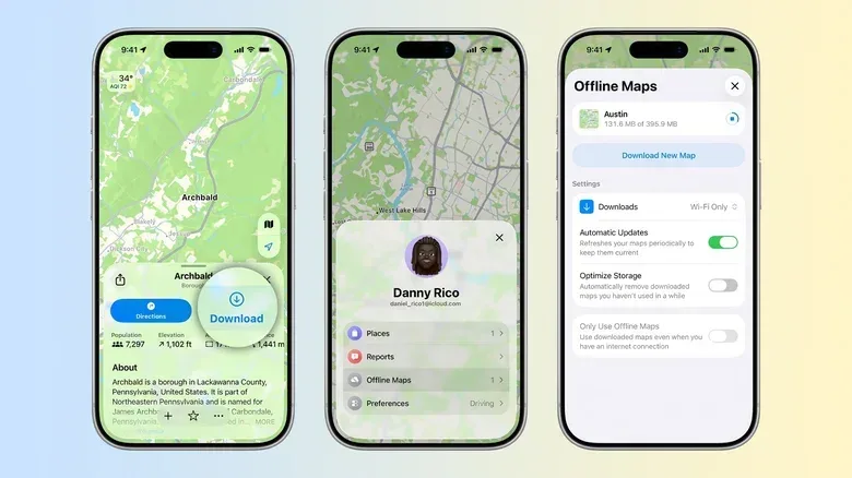
Offline Maps lets users save a chosen map region directly to an iPhone. The practical benefit is straightforward: navigation is less dependent on Wi-Fi or cellular coverage once a trip begins. That matters when travelling through areas with poor reception, but it can also be useful for anyone managing a limited mobile-data plan.
The downloaded region includes more than a static street image. Apple Maps can retain place ratings, estimated arrival times and turn-by-turn directions for offline use. In other words, it is designed to preserve the core information needed to find a destination and follow a route rather than merely displaying a visual reference.
To save an area, open Apple Maps, tap the profile picture beside the search field and select Offline Maps. From there, choose the region to download. The app also offers an Only Use Offline Maps control. That setting is particularly relevant for people who want to avoid using mobile data while travelling, though it also means the app will lean on the stored region rather than live connectivity.
The key distinction is between offline routing and real-time road awareness. A downloaded map is valuable because it keeps essential navigation available without a signal. However, live conditions inherently depend on current information. Before leaving a place with reliable connectivity, it is sensible to make sure the needed region is stored and to check the route while the app can still retrieve current conditions.
A small pre-trip routine with a large payoff
- Open Maps while connected to Wi-Fi or cellular service.
- Download the region covering the journey and likely detours.
- Confirm that the destination can be found in the saved area.
- Decide whether Only Use Offline Maps fits the trip or data plan.
That preparation is especially useful when the phone is serving as both navigator and travel companion. Keeping it powered is a separate consideration, and readers planning a road setup may also find our comparison of charging-power and accessory priorities useful.
Use Notes to give places your own context
Search listings are good at identifying an address, but they do not always capture why a specific place mattered to you. Apple Maps’ Add a Note function fills that personal gap. A note can be attached to a location by opening its place card, tapping the three-dot menu and choosing Add a Note.
Related coverage includes Apple Maps Features to Set Up Before Your Next Drive or Trip.
Apple says these notes are private, meaning they are not published for other Maps users to see. That makes the feature more like a personal location notebook than a public review system. It could be useful for remembering a recommended order, an entrance that was easier to find, a detail about a venue, or simply why a saved location is worth revisiting. The information reappears when that location is opened again in Maps.
The important technical distinction is that a note is attached to the place entry, while a saved location history is about recording where you have been. They solve related but different problems. Notes add meaning to a location; history can help recover the location itself.
Visited Places can act as a private memory aid
Visited Places is aimed at the familiar situation of remembering a café, shop or venue but not its name. When enabled, Maps automatically keeps track of locations you visit. The resulting list is accessible under the Places section in the app.
Users can choose how long to retain those entries: three months, one year or indefinitely. The setting can be found on iPhone through Settings > Apps > Maps > Location Services, where the Visited Places toggle can be switched on.
This is a convenience feature with an obvious privacy dimension. A visit history can be helpful precisely because it creates a record of movements over time. Anyone considering it should choose the retention period that matches their needs rather than treating “forever” as the default. Three months may be enough for recovering recent stops, while a longer period may suit people who regularly return to the same cities or want a broader personal reference.
Availability is regional, so the feature may not appear on every iPhone. The settings path is therefore useful for two reasons: it enables the option where supported and provides a quick way to see whether it is offered locally.
Let Maps anticipate a routine drive—within its limits
Apple Maps can learn preferred routes and predicted destinations, allowing an iPhone to warn about heavy traffic before departure or propose an alternative route. This is controlled in Settings > Maps > Location through the Preferred Routes and Predicted Destinations toggle.
In plain language, this is Maps attempting to recognize recurring travel patterns. If a person often takes the same route, the app can use that context to surface traffic-related information before they manually start navigation. It is not a guarantee that every trip will be predicted correctly, nor does it replace checking directions when plans change. Its value is reducing the number of times a routine journey needs to begin with a fresh search.
Apple says the route information used for this function is not tied to an Apple Account. That statement addresses a common concern around route-learning features: useful predictions require some form of location context, but Apple says that context is not associated with the user’s account.
As with Visited Places, regional support matters. If the toggle is missing, that does not necessarily indicate a problem with the phone; the feature is limited to certain locations.
Make the parked-car pin part of the exit routine
For many people, the most useful mapping feature is the one that avoids an unglamorous end-of-day problem: finding the car again. Apple Maps can automatically drop a parked-car marker after the driver disconnects from CarPlay and leaves the vehicle. Enable it through Settings > Apps > Maps by turning on Show Parked Location.
This is a simple automation, but it is most helpful in exactly the places where memory is least dependable: multi-level parking structures, unfamiliar streets, large event lots and busy shopping areas. The feature does not need a full route to be useful; it just turns the point where the CarPlay session ends into a location reference.
Drivers who do not use CarPlay still have a manual alternative. Press and hold the Maps icon on the iPhone Home Screen, then select Mark Your Location. That places a pin at the current position. The manual method is worth remembering because it gives the user control in situations where the automatic CarPlay trigger is irrelevant.
Report hazards with Siri while staying focused on driving
Maps also supports voice reports for road incidents. During a drive, a user can say, “Siri, there’s an accident ahead” or “there’s something on the road”. Siri can submit the report for other drivers using Maps.
The supported incident types include accidents, speed checks, heavy traffic and road closures. This is a crowd-informed road-awareness tool: the usefulness of a report is tied to its relevance and timeliness for other people on that stretch of road. Its design is notable because it allows a driver to contribute without manually operating the phone.
Voice reporting should remain secondary to the road itself. The advantage of Siri here is not that it creates a reason to interact with a device while driving; it is that a brief hands-free report is available when it can be made safely. Support for these reports can vary by location, so drivers should not assume every incident category will be available everywhere.
Which settings are worth enabling first?
- Offline Maps: Start here before any trip that could involve limited signal or data.
- Show Parked Location: A low-effort option for CarPlay users who routinely park in unfamiliar places.
- Preferred Routes and Predicted Destinations: Best suited to recurring commutes and regular drives, where advance traffic warnings can matter.
- Add a Note: Useful when a location’s personal details are more important than a public rating.
- Visited Places: Helpful for recovering names of past stops, provided the selected retention period feels appropriate.
Apple Maps’ history includes a difficult 2012 launch, but its present feature set is broader than that old reputation suggests. The most useful tools are not necessarily the flashiest 3D views or AI-enhanced experiences. They are the settings that reduce friction before a drive, preserve directions when service disappears, remember a parking spot, and make an iPhone’s map a little more personal without making its interface more complicated.